


Explore how our innovative solutions have empowered the below businesses
worldwide to achieve their ambitious goals.
By tracking how people moved and where they stopped, this council improved how the district was managed.
Find out how →
With pedestrians, cyclists, buses and cars all competing for space, this major transport authority needed a clearer picture of what was happening day to day.
Read the full story →

Event peaks, quiet periods, and seasonal changes made this busy district hard to manage until long-term dwell time data filled the gaps.
Read the full story →

Rapid growth left staff guessing which shared spaces were busiest, leading to missed opportunities and maintenance needs until real-time usage data was introduced.
Find out how →
Explore how our innovative solutions have empowered the below businesses
worldwide to achieve their ambitious goals.
By tracking how people moved and where they stopped, this council improved how the precinct was managed.
Find out how →
With pedestrians, cyclists, buses and cars all competing for space, this major transport authority needed a clearer picture of what was happening day to day
Read the full story →
Event peaks, quiet periods, and seasonal changes made this busy precinct hard to manage until long-term dwell time data filled the gaps
Check out the impactful change →
Rapid growth left staff guessing which shared spaces were busiest, leading to missed opportunities and maintenance needs until real-time usage data was introduced.
See what changed →
By tracking how people moved and where they stopped, this council improved how the precinct was managed.
Find out how →
With pedestrians, cyclists, buses and cars all competing for space, this major transport authority needed a clearer picture of what was happening day to day.
Read the full story →
Event peaks, quiet periods, and seasonal changes made this busy precinct hard to manage until long-term dwell time data filled the gaps.
Read the full story →
Rapid growth left staff guessing which shared spaces were busiest, leading to missed opportunities and maintenance needs until real-time usage data was introduced.
Find out how →
LoRaWAN is a registered trademark of the LoRa Alliance. All other trademarks are the property of their respective owners.

A leading residential property developer and operator specializing in retirement and resort living, residential leasing, student housing, and specialized disability housing has experienced significant portfolio growth over the past three years.
Recognized for innovation in lifestyle-led communities, the organization has invested heavily in advanced building management systems and sustainability initiatives, earning multiple awards for excellence in urban development, construction, and master planning. Resident comfort, safety, and overall experience remain central to its operating model.
As the portfolio expanded, the organization required deeper, data-driven insight into how shared spaces were being used. This included understanding occupancy levels, movement patterns, and dwell times across cafés and bars, movie theaters, wellness and pool areas, dining rooms, lounges, reception areas, fitness centers, and recreation rooms.
Existing approaches lacked the accuracy, scalability, and cost efficiency needed to support day-to-day operational decision-making. The organization sought a low-cost, privacy-preserving solution capable of delivering reliable, real-time insights through a centralized dashboard to optimize maintenance, staffing, and service delivery.
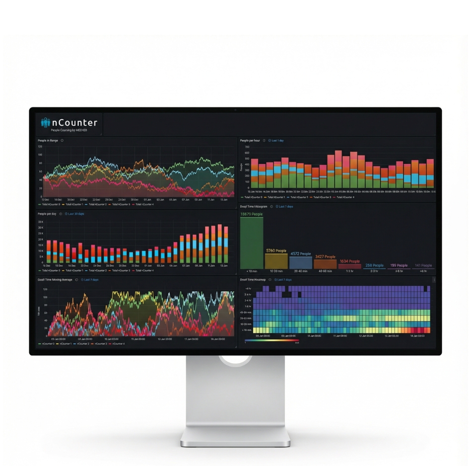
Meshed deployed nCounter people-counting devices alongside motion and indoor air-quality sensors across two flagship properties. Indoor LoRaWAN gateways provided reliable coverage across all shared spaces, enabling rapid deployment with minimal disruption.
Data began flowing within days to Meshed’s secure, cloud-hosted dashboard, where facilities teams configured tailored dashboards, alerts, and reports using a flexible, user-friendly interface.
Access to real-time space utilization data delivered maintenance cost savings of up to 20%, with cleaning, servicing, and staffing aligned to actual usage patterns. Operational efficiency improved, while resident experience was enhanced through more responsive and informed resource allocation.
Measurable cost savings, improved service delivery, and a scalable, data-driven approach to managing premium residential living environments.
A leading residential property developer and operator specializing in retirement and resort living, residential leasing, student housing, and specialized disability housing has experienced significant portfolio growth over the past three years.
Recognized for innovation in lifestyle-led communities, the organization has invested heavily in advanced building management systems and sustainability initiatives, earning multiple awards for excellence in urban development, construction, and master planning. Resident comfort, safety, and overall experience remain central to its operating model.
As the portfolio expanded, the organization required deeper, data-driven insight into how shared spaces were being used. This included understanding occupancy levels, movement patterns, and dwell times across cafés and bars, movie theaters, wellness and pool areas, dining rooms, lounges, reception areas, fitness centers, and recreation rooms.
Existing approaches lacked the accuracy, scalability, and cost efficiency needed to support day-to-day operational decision-making. The organization sought a low-cost, privacy-preserving solution capable of delivering reliable, real-time insights through a centralized dashboard to optimize maintenance, staffing, and service delivery.
Meshed deployed nCounter people-counting devices alongside motion and indoor air-quality sensors across two flagship properties. Indoor LoRaWAN gateways provided reliable coverage across all shared spaces, enabling rapid deployment with minimal disruption.
Data began flowing within days to Meshed’s secure, cloud-hosted dashboard, where facilities teams configured tailored dashboards, alerts, and reports using a flexible, user-friendly interface.
Access to real-time space utilization data delivered maintenance cost savings of up to 20%, with cleaning, servicing, and staffing aligned to actual usage patterns. Operational efficiency improved, while resident experience was enhanced through more responsive and informed resource allocation.
Measurable cost savings, improved service delivery, and a scalable, data-driven approach to managing premium residential living environments.

A major riverside entertainment and retail district, located minutes from downtown in a large Australian capital city, attracts a diverse mix of residents, tourists, commuters, and eventgoers throughout the year. Designed as an eclectic destination with dozens of businesses, dining venues, and live entertainment, the district operates extended hours and supports adjacent ferry services, shared pedestrian and cycling paths, and nearby residential communities.
Managing a district of this scale required accurate, long-term insight into how people moved through and used the space—across peak events, seasonal variations, and quieter non-trading periods. District operators and the state development agency needed reliable data to support operational planning, maintenance scheduling, event management, and future investment decisions, without relying on manual counting, costly infrastructure, or privacy-sensitive technologies.
A privacy-first, LoRaWAN-based people-counting solution was deployed across the district and surrounding riverfront areas. Low-cost sensors were installed on buildings and light poles using a combination of grid and solar power. The solution delivered fully anonymized, aggregated foot traffic and dwell-time data to a secure, cloud-hosted dashboard, operating continuously with minimal infrastructure and no impact on visitor privacy.
Over multiple years of operation, the solution has provided 24/7 insight into visitor volumes, movement patterns, and space utilization. These insights have supported smarter event planning, improved maintenance efficiency, and informed long-term district planning. The data has helped guide decisions related to future residential development, hospitality expansion, transportation access upgrades, and broader district revitalization initiatives.
Evidence-based decision-making, reduced operational uncertainty, and a scalable, privacy-safe approach to understanding how people use complex public spaces.

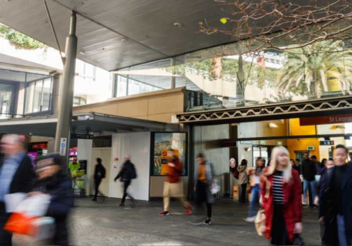
A major transportation authority, working in partnership with a City government, launched a pilot program to better understand how people and vehicles move through a high-activity transportation district. The area included a major railway station, surrounding sidewalks and cycling routes, bus stops, taxi and loading zones, on-street parking (including accessible parking spaces), and adjacent hospital, education campuses, and parkland areas.
The project aimed to collect accurate, real-time data over a six-month period to support more effective planning and management of highly contested curbside and public-realm assets.
Urban transportation districts face increasing pressure from competing demands across pedestrians, cyclists, public transit, private vehicles, and service providers. Without reliable, continuous utilization data, it is difficult for transportation planners to allocate space equitably, improve safety outcomes, and optimize network performance across different times of day and peak periods. Traditional surveys and manual counts provided only limited snapshots and were insufficient for long-term, evidence-based planning.
The transportation authority engaged Meshed to deploy more than 100 IoT sensors across the district, including nCounter people-counting devices, smart parking sensors, and urban heat monitors. nCounter devices were installed at station entrances and exits, pedestrian overpasses, sidewalks, and bus stops, delivering continuous, fully anonymized pedestrian movement and dwell-time data via LoRaWAN.
The project delivered a clear, real-time understanding of how the district was used, supporting improved curbside allocation, safer pedestrian and cyclist movement, enhanced transit network performance, and data-driven planning that improved accessibility, inclusion, and economic activity across the district.
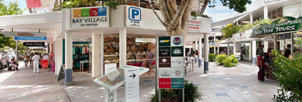
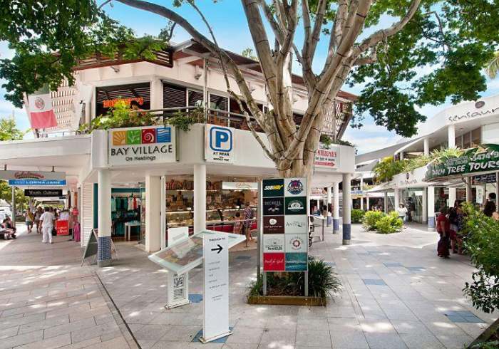
A premier international holiday destination renowned for its pristine beaches and year-round warm climate attracts high visitor volumes, particularly during Christmas, New Year and school holiday periods. Its vibrant main street shopping districts are popular hubs for dining, retail and entertainment, serving both tourists, local businesses and residents.
The City government has been an early adopter of smart city initiatives for more than a decade, earning multiple innovation awards. As part of its ongoing digital transformation program, the City deployed interactive digital wayfinding kiosks with large-format displays to promote local traders, events, attractions and visitor information across key tourism districts.
The City needed to ensure the interactive kiosks were positioned for maximum visibility and engagement while also supporting broader district management. Key objectives included understanding real-time pedestrian volumes, helping traders align opening hours with peak footfall, measuring dwell times around seating and landscaped areas, optimising cleaning and amenity servicing, managing parking and traffic demand, and evaluating the impact of markets and community events.
The solution needed to be accurate, discreet, aesthetically aligned with kiosk design, powered directly from the kiosk, and operate without collecting personal data or using camera-based technology.
Building on its existing deployment of more than 30 nCounter devices, the City integrated a privacy-preserving nCounter sensor directly into the digital kiosk design. Installed within a purpose-built IP67-rated enclosure, the device is powered by the kiosk and transmits anonymised footfall and dwell data via LoRaWAN to Council’s dashboard.
Data began reporting immediately, delivering 24/7 insight into pedestrian movement and dwell behaviour. The insights now inform future kiosk placement, trader operating hours, downtown district activation, transportation planning and service delivery. The City also plans to share insights with local traders and the community, supporting evidence-based placemaking, economic vitality and an improved visitor experience.